The Portland MSA or "The Metro"
The Portland Metro Area is located in the Northwest corner of Oregon in the Pacific Northwest
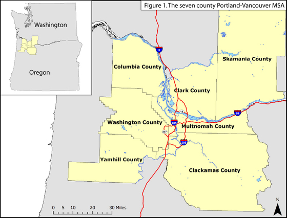
The Portland MSA (Metropolitan Statistical Area) is comprised of five Oregon counties and two counties from Washington State. They are: Columbia, Washington, Yamhill, Multnomah, and Clackamas counties in Oregon, and Clark and Skamania counties in Washington State.
Portland is located along the Willamette and Columbia Rivers. Originally founded as an inland port that could harbor ocean going ships (with a little dredging) it has transformed into a young, progressive and technical metropolitan area.
It has a total population of 2,300,000 persons, with a population density of 333persons per square mile. Most of these individuals are located within the regions largest cities; Portland, OR, Vancouver, WA, Gresham, OR, and Hillsboro, OR.
The area is home to the Portland Trail Blazers of the NBA.
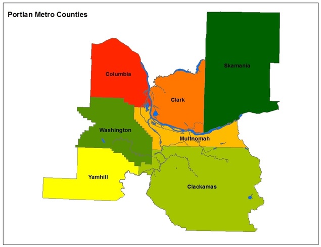
Metro Counties
The Portland Metropolitan Area contains 7 counties:
1. Skamania: located in the State of Washington, this county has a population of 11,000. 90% of the county is forested. It has a total area of 1,684 square miles. It's largest industry is construction, mostly because of the areas suburban, residential nature needing more housing built. Mt. St. Helens is located in Skamania County.
2. Clark: located in Washington, Clark county is named after William Clark from the Lewis and Clark Expedition. It has a population of 438,000 and a total area of 656 square miles. Its largest Industry is construction, with other focuses in manufacturing, wholesale trade, and health services. It contains the city of Vancouver, the metro area's second largest city.
3. Columbia: located in Oregon, Columbia county was named after the Columbia river which forms two of its borders. It has a population of 49,000 and an area of 688 square miles. Its largest industry is retail and wholesale trade, fueled mostly by the paper manufacturing that takes place there.
4. Washington: the second most populous county in Oregon with 530,000 persons and an area of 726 square miles. It's economy is mostly fueled by the presence of Intel and other electronics manufacturers in the city of Hillsboro. Nike is also based in Washington County.
5. Yamhill: a mostly rural county to the southwest of Portland, Yamhill has a population of 99,000 persons and an area of 718 square miles. Its largest industry is healthcare assistance, but its western portions are a large producer of timer products.
6. Multnomah: Oregon's most populous county, it is home to 735,000 persons, and with an area of 435 square miles it is also its most dense. The city if Portland is contained in Multnomah county, accounting for most the population. Its largest industry is healthcare, but also has a large presence of trade, manufacturing and profession and technological services.
7. Clackamas: is the largest county in the metro area wise with 1,879 square miles. The county has a population of 376,000 persons. It contains Mt. Hood, the only year round ski resort in the nation. It's largest industries are manufacturing, trade, accommodation services, and healthcare and social assistance.
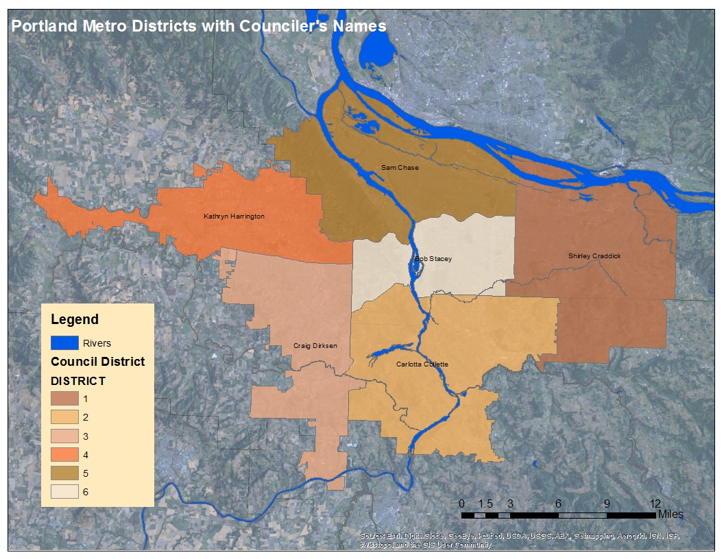
Metro Districts
The Portlad Metro contains 6 different "Districts"
1. District 1 will include all of Fairview, Gresham, Troutdale, Wood Village and Damascus, Boring and unincorporated areas in Multnomah County east of Gresham and Troutdale. It will also include all of Portland east of 122nd Ave. (and east of 112th Ave. south of Foster Road). District 1 will no longer include the cities of Happy Valley (now in District 2) and Maywood Park (now in District 5).
2. District 2 will include all of Happy Valley, Gladstone, Johnson City, Lake Oswego, Milwaukie, Oregon City, Rivergrove and West Linn, along with many unincorporated areas in northern Clackamas County. It will also include a portion of Southwest Portland and unincorporated Multnomah County to the east and south of Interstate 5 and south of SW Canby Street east of Brier Place. The district will include all of the Stafford area within Metro’s jurisdiction (the portion of Stafford south of Interstate 205 was previously in District 3).
3. District 3 will include all of Beaverton to the south of Beaverton-Hillsdale Highway/Farmington Road east of Watson St., south of Broadway between Watson St. and Cedar Hills Blvd., and to the south of Tualatin Valley Highway west of Cedar Hills Blvd. It also includes of Durham, King City, Sherwood, Tigard, Tualatin and Wilsonville, plus the unincorporated communities of Aloha (south of Tualatin Valley Hwy., which was previously in District 4), Raleigh Hills (south of Beaverton-Hillsdale Hwy.), Bull Mountain, Garden Home and Metzger. It will no longer include any portion of Stafford.
4. District 4 will include all of Forest Grove, Cornelius and Hillsboro. It will also include a portion of Beaverton and unincorporated areas in Washington County to the north of Beaverton-Hillsdale Hwy./Farmington Rd. east of Watson St., north of Broadway between Watson St. and Cedar Hills Blvd., and to the north of Tualatin Valley Hwy. west of Cedar Hills Blvd., except for the community of Cedar Mill lying north of U.S. Hwy. 26 and north and east of Beaverton city limits, which will become part of District 5. District 4 will include the unincorporated communities of Aloha (north of Tualatin Valley Highway), Raleigh Hills (north of Beaverton-Hillsdale Highway), Bonny Slope, Bethany, West Slope and Cedar Hills. District 4 will be entirely within Washington County.
5. District 5 will include all of North and Northwest Portland, all of Southwest Portland north of U.S. Hwy. 26 (including downtown), and all of Northeast Portland north of Interstate 84 and west of 122nd Ave. District 5 will include Maywood Park, which was previously in District 1. District 5 will also include an area in Washington County north of Hwy. 26 and north and east of the Beaverton city limits (the Cedar Mill area), which was previously in District 4.
6. District 6 will include all of the east side of Portland south of Interstate 84 and west of 122nd Ave. (except for the portion south of Foster Rd. and east of 112th Ave., which will be in District 1). District 6 will also include all of Southwest Portland south of U.S. Hwy. 26, west and north of Interstate 5 and north of Canby St. east of Brier Pl. District 6 will be entirely within Multnomah County.
